The Bow Fiddle Rock is near to Portknockie, a small cliff-top fishing village on the Moray coast between Findochty and Cullen, that overlooks the Moray Firth.
The sea around Portknockie is home to dolphins and many sea birds. and it is where the Bow Fiddle Rock can be seen and photographed. The rock is so called because it resembles the very tip of a bow. It was formed by erosion of a rock called Cullen Quartzite which is one of the many types of quartzites found around Scotland. Cullen quartzite is about 2500 metres (8000 feet) thick and makes up the coastline from Buckpool (the west end of Buckie) to Logie Head, the main headland east of Cullen.

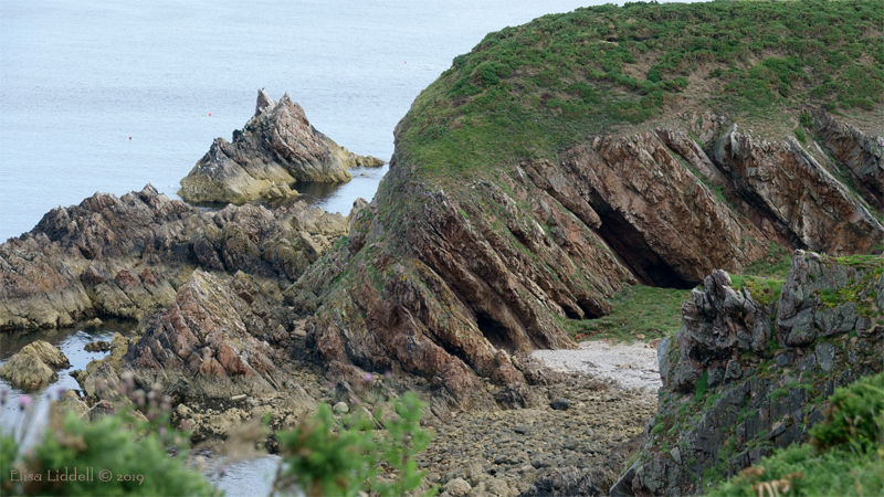
As you leave the village and walk towards the Bow Fiddle, you can clearly see that the entire coastal cliff structure has the same steep downward angle. This has been formed over many millions of years, and is visible evidence of the fact that Scotland and England were once part of different ‘continents’ that collided and made the distinctive Scottish Geology and geography!
I’ll let Scottish Geology.com explain
“Quartzite is a metamorphic rock, which means that it has been altered in nature by heat or by pressure. It was originally sandstone laid down in layers under the sea around 750 million years ago. More and more sediment piled up on top until the sandstone was buried several kilometres down, and as the pressure from overlying rocks built up, and heat from the centre of the Earth rose into the crust, the grains of silica in the sandstone were crushed and welded together to form the much harder rock called quartzite.
Movements of the tectonic plates which make up the surface of the Earth also had an effect. Scotland lay on the edge of an ancient continent called Laurentia, and another continent called Avalonia, on which what is now England lay, was carried towards Laurentia and eventually the two continents collided. The result was to crumple and fold the strata of rock, which is why the rock layers making up the Bow Fiddle Rock slope down to the south.
Over millions of years the overlying rocks were eroded away again, and the Cullen Quartzite became exposed at the surface, where the sea and the weather began to attack weaker spots in the rock and carve out the arch we see today. The sloping layers can be traced on to the land from which you first see the Rock. From further east along the clifftop, you get a completely different view, where you can see that the Rock is a long sloping slab of rock.
source: Scottish Geology.com

As you walk along the cliff top path, the Bow Fiddle rock begins to appear, very much aligned with the mainland cliffs. You can walk round the headland, or scramble down the narrow track to get a sea level view.

From the seashore the rock towers out of the water, and the surrounding sound is of the seagulls and other birds that inhabit the rocks and cliffs all along this stretch of coast. When I was shooting these photos the sea was calm and tranquil, and the midday sun cast strong shadows.

Once you have seen the effects of the massive collision between the two continents, you can recognise the distinctive sloping layers and steeply angled rock formations all along this stretch of coast.

Here, just a mile along the coast from the Bow Fiddle, the same steep angle is clearly visible. It is fascinating and awe-inspiring to imagine the forces at work over 500 million years ago that have given us this wonderful, sculptural coastline!
© 2019 Elisa Liddell
My Photographic section – Talking Digital Photography
My Photography Blog
Flickr holds my online Photo Gallery of over 2,600 photos shot with a variety of cameras and lenses
